


les puechs

roudiereodile
User
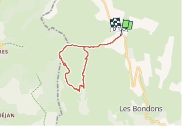

Length
6.7 km

Max alt
1201 m

Uphill gradient
276 m
Km-Effort
10.4 km

Min alt
938 m

Downhill gradient
272 m
Boucle
Yes
Creation date :
2023-03-11 12:59:07.118
Updated on :
2023-03-11 15:09:09.327
1h53
Difficulty : Medium

FREE GPS app for hiking
 SityTrail
IGN / Geographical institutes
SityTrail Plus
The world is yours!
About
Trail Walking of 6.7 km to be discovered at Occitania, Lozère, Les Bondons. This trail is proposed by roudiereodile.
Positioning
Country:
France
Region :
Occitania
Department/Province :
Lozère
Municipality :
Les Bondons
Location:
Unknown
Start:(Dec)
Start:(UTM)
548772 ; 4916877 (31T) N.
Comments